Landslide Risk Analysis with ArcGIS (AHP)/Complete Task
Published 08/2022
MP4 | Video: h264, 1280x720 | Audio: AAC, 44.1 KHz, 2 Ch
Genre: eLearning | Language: English | Duration: 35 lectures (4h 38m) | Size: 2.95 GB
Learn how to find Landslide Risk Zones for Any of the Study Area/Complete Task
What you'll learn
Multi Criteria Decision Analyse
ArcGIS Basic and complex Functions
ArcGIS Spatial Analysis Methods
How to use Geoprocessing Tools
Project GIS Datas
How to manage Landslide Risk Analyse Criterias
Raster-Vector Conversions (Batch function)
Vector-Raster Conversions/Dissolve Function
Weighted Overlay Analyses
Buffer Analysis
Hydrology Analysis
Cartographic Design
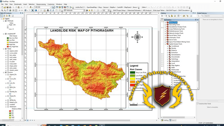
Identify Landslide Risk Zones
Learn How to make surface analysis
Watershed Analysis From the zero
Area calculation from the pixels
Raster Reclassification
Working with Rainfall Datas
Raster Processings (Mosaic,Clip Digital Elevation Map)
Working with CDF file and data Extraction, Map Generation, Calculation
Remote Sensing Tecniques (Main)
Interpolation Tech
More and More...
Requirements
Main Computer Knowledge
Main GIS Knowledge
ArcGIS 10.X
Desire and attention
Description
I will teach you how to detect Potential Landslide Risk Areas for ANY STUDY AREA in the world.
Im sharing AHP Excel Sheet with you! By the way , you can also be able to detect different risk analyses for ANY of Study Area.
The weights and effects of 10 different layers were calculated for the landslide risk analysis with the AHP multiple decision making method. The use of Geographic Information Systems (GIS) in risk analysis studies is increasing day by day.
In the course I prepared for Landslide Risk Analysis with ArcGIS, I will show you how to determine from scratch in detail the Landslide Risk Analysis with AHP in a place of India, with a high probability of Landslide Risk disaster using the "Multiple Decision Criteria" method.
Throughout the course, you will be actively introduced to ArcGIS Basic commands and how to use complex spatial analysis techniques in the following sections.
* Thematic Map layer creation,
*Raster operations (cutting, merging, DEM data according to the border),
*Classification of raster data (Reclassify)
*Defining a common projection system for Map Layers,
*Dissolve process (Integration by Grid Code)
*Conversion from raster to vector/vector to raster (Conversion automaticly/not MANUALY)
*Using Batch command for dissolve/conversion proccess
*Interpolation method,
*Geoprocessing operations, raster analysis,
* Exporting vector and raster data in the desired coordinate system,
* Modeling the analyzes that we will make using Model Builder,
*AHP method
*Weighted Overlay Analyze
*Area calculation of criteria *
*More processes such as Cartographic Design and printing will be explained to you in detail.
Unlike other courses, you will learn to prepare using the AHP by using AHP excel sheet in order to calculate the weights of the basic criteria we will use for the analysis (finding the effect of the criteria on the analysis), and you will be able to print your standart maps with quality cartographic designs.
Who this course is for
Cartographers
Urban Planners
Geomatics Engineers
Geology Engineers
Water Management and Engineers
Hydraulic Engineers
GIS Experts
Homepage
Screenshots
Welcome to My Blog - Check it Every Days
If you have any troubles with downloading, PM me
Please Buy Premium Account from my links to get high download speed and support me
Happy Learning!!
Download from free file storage
Resolve the captcha to access the links!
Registered members don't get captcha ... just sayin